

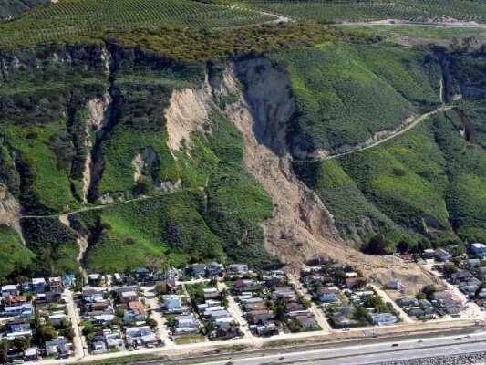
Santa Barbara County, California – Landslide Photo – USGS
Landslides can occur in all 50 states. They can be sudden and shockingly deadly. Are you vulnerable?
It’s Wednesday November 28th. I’m watching the weather reports today. Here’s a sample of the local headlines – this one from ABC. today:
Storm system will bring rain to SoCal starting Wednesday evening with heavier downpours expected overnight and into Thursday morning, causing flooding concern for residents in the recent burn areas.
This led me to an older news report. This one was also from California, back in January 2018:
For days, officials advised residents in areas burned by the Thomas fire that a coming storm could bring major mudflows. Several neighborhoods were under a voluntary evacuation order. Many residents decided to stay. Some assumed the threat was overblown just weeks after the fire triggered similar calls to evacuate.
And the result: At least 21 people were killed by the flooding and debris flows at followed the heavy rains.
Have you experienced heavy rains yet this season? If yes (or even if no), are you vulnerable to landslides?
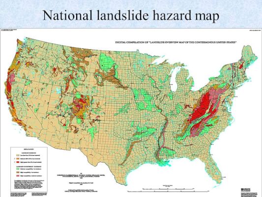
Take a look at this map from the US Geological Survey, showing regions of vulnerability. As you can see, they are mostly along the west coast of the US and also in the eastern mountains.
The bright red Appalachian Mountains area is labeled as having 15% of the land vulnerable to mud and landslides!
How do you protect against landslides?
Much of the following information was provided via resources suggested by one of Emergency Plan Guide’s readers. Thanks, Bradley Davis at DisasterWeb.net. !
Learn more about your risks beforehand.
- Check on detailed maps like the one above from the USGS to see if you are vulnerable to landslides, and if so, just how vulnerable you are. Maps are based on geographic features, soil properties and historic and anticipated rainfall.
- Second, be aware of recent fires that may have raised the risk in an area that otherwise might not have been so risky. Note: you may be traveling into a higher risk area that will make you more vulnerable. Find out what’s been going on there recently!
- Check with your insurance agent to find out if you have coverage for mudflows. Unless you have Flood Insurance, you probably don’t!
Be ready to evacuate.
Have an evacuation plan and evacuation kits. You may have very little notice so be prepared to leave IMMEDIATELY and know where you’re headed or at least how to get in touch with other family members. (That out-of-state emergency contact, remember?)
Take action now to protect your property.
You can’t stop the rain. But you can take steps to control and redirect water on your property. Some examples:
- Consider plants and trees that have deep roots, to control erosion and to help absorb and filter water.
- Landscape to include depressions/channels to direct runoff. The water needs to end up on your property, remember.
- Build a “rain garden” to catch and hold water, where it can soak into the ground within 24 hours. Plants in the garden need to be wet-soil tolerant and have deep roots. Get professional assistance in planning this depression. Find more info and great photos of rain gardens at the Groundwater Foundation.
- Divert water from rain spouts so it doesn’t collect and make puddles.
- Build up grass and natural barriers at the perimeter of your property to keep water out or redirect it.
- Install permeable paving and porous surfaces in driveways and walkways.
Know the signs of impending danger.
As always, be alert to your surroundings. Some indications that land may be starting to shift, signalling a potential landslide . . .
- Strange sounds – trees cracking, rocks clashing, water flowing rapidly.
- New cracks or bumps in roads, on slopes.
- Soil moving away from foundations, road bed dropping.
- Saturated ground where it is usually dry.
- Tilted trees, decks, fences or walls.
Watch the weather reports, and be ready to leave at a moment’s notice!
Finally, if you do have to evacuate as a result of landslide, before you head back in . . ..
Even if things look OK at first, be cautious before you assume anything. Check with authorities that are on site to see if Personal Protective Equipment is required or desirable. (Direct Relief, a disaster relief organization, is providing coveralls to victims of California fires right now.)
At the very minimum, wear heavy rubber boots, long pants and long sleeves, heavy work gloves, and use a mask (N95) to protect against breathing in contaminated dust and/or ash.
Approach your “re-entry” step by step.
- If your home suffers structural damage, take photos and contact your insurance agent. Keep receipts for any clean up and repairs.
- Utilities may be off or damaged. Check for gas leaks, broken wires or the smell of burning insulation. Check for broken water and sewer pipes. Call on professionals for help turning these back on.
- Everything that got wet may be a health hazard. Disinfect (Bleach is the best) and then dry. Wear gloves, mask and eye protection against dust, chemicals, mold.
- Watch out for rashes as a result of exposure to debris. Watch for “trench foot” as a result of having wet, cold feet hour after hour.
- Any cut or even breathing contaminated air may turn into a serious infection. Check your condition frequently and don’t delay in seeking medical advice.
When many people are displaced and living in local shelters, the chance of contagious diseases is also increased. Again, use respiratory and eye protection to help prevent the spread of germs, and be aware of hygiene at all times.
Wow. So how vulnerable are you?
What started out as an extended weather report has turned into quite a lengthy discussion. If you are outside of a potential slide area, perhaps you can forward this Advisory to friends elsewhere. If you’re not SURE whether you are in a slide area, head back to the USGS and see if you can dig into their maps for more detailed info about YOUR location.
If you’ve been affected by recent fires in California, you may also want to check out some of the FAQ (Frequently Asked Questions) at the USGS. Here’s one specifically about wildfires and debris flows. And here’s even more detail about Southern California susceptibility.
The latest weather update . . .
So I just checked with the National Weather Service. They have issued a FLASH FLOOD WATCH for my area and in particular for burn scar areas, for tomorrow, Thursday morning through Thursday night.
Here’s the message:
Heavy rainfall could cause debris flows in recent burn areas according to rainfall thresholds provided by the USGS. Debris flows are extremely dangerous and happen suddenly often with little time to act. It may even not be raining at your location to be impacted by a debris flow. You should monitor the latest forecasts. Heed any advice given from local authorities.
This is real life.
Virginia
Your Emergency Plan Guide team
Don't miss a single Advisory.
Thank you for subscribing.
Something went wrong.